Tuesday night will be dry with clear spells and lowest air temperatures 6°C to 9°C.
Apart from a few scattered showers, chiefly in eastern areas, another dry day is in store on Wednesday with sunny spells. Highest temperatures 12°C to 15°C in moderate to fresh easterly winds. Good drying. Dry and cool on Wednesday night. Lowest air temperatures 4°C to 9°C with ground temperatures dipping just below zero in some rural areas.
Thursday will be a cool, breezy day with some sunny spells. Scattered showers also in the east and south but mainly dry. Highest temperatures 12°C to 14°C. Fresh easterly winds will ease throughout the day and there is a risk of ground frost in rural areas early Thursday night with clear spells.
Current indications are that Friday morning will be mostly dry then a band of rain will gradually extend eastwards from the Atlantic, with quite heavy rainfalls possible in the west and southwest.
At the moment next weekend looks changeable.
Rain
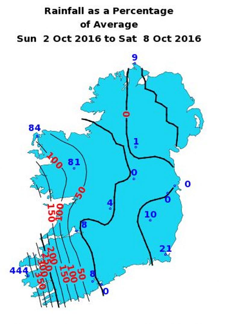
County Kerry, as a whole, recorded between 200% and 450% of normal rainfall for the start of October. Even more remarkable is that these totals accumulated during one 24 hour period at the beginning of last week, with Valentia Observatory recording its highest daily total since records began there in the 19th century. Other western parts of the country recorded normal or slightly above normal totals last week but many other places had little or no rain.

During the coming week, all parts of the country are likely to receive normal amounts of rainfall for the time of year. Once again, the southwest is likely to be wettest with up to 200% of normal being recorded. However, this volume of rain will be spread more or less evenly over the days from next Wednesday on.
Temperatures
In general, mean air temperatures were above normal by between 0.5°C and 1°C during the week gone by. Most places will see mean air temperatures staying above normal during the coming week but only by a small margin.

Mean soil temperatures are currently 1°C or 2°C above normal, and little change is likely in these values in the coming days.
Sunshine
Aside from the very wet southwest portion of the country, last week saw all areas recording near normal sunshine hours. The prospect of mixed weather developing during the coming week is likely to limit sunshine in most places.
Drying conditions
Mid-autumn is the time of year when good drying becomes less and less likely in Ireland. The anticipated changeability in the offing will make for mostly poor drying after Tuesday next.
Spraying
Conditions will remain good for effective spraying operations today but increasing wind on Tuesday and Wednesday will hamper this work. Thereafter, the combination of wind and regular rainfall will likely prevent spraying.
Field conditions
Trafficability will remain testing on poorly drained lands. For the time being, well drained and moderately drained soils are maintaining good trafficability. However, this is likely to deteriorate significantly by the end of the week.
Read more
Watch: Wet weather hampering slurry progress in the west
Tuesday night will be dry with clear spells and lowest air temperatures 6°C to 9°C.
Apart from a few scattered showers, chiefly in eastern areas, another dry day is in store on Wednesday with sunny spells. Highest temperatures 12°C to 15°C in moderate to fresh easterly winds. Good drying. Dry and cool on Wednesday night. Lowest air temperatures 4°C to 9°C with ground temperatures dipping just below zero in some rural areas.
Thursday will be a cool, breezy day with some sunny spells. Scattered showers also in the east and south but mainly dry. Highest temperatures 12°C to 14°C. Fresh easterly winds will ease throughout the day and there is a risk of ground frost in rural areas early Thursday night with clear spells.
Current indications are that Friday morning will be mostly dry then a band of rain will gradually extend eastwards from the Atlantic, with quite heavy rainfalls possible in the west and southwest.
At the moment next weekend looks changeable.
Rain
County Kerry, as a whole, recorded between 200% and 450% of normal rainfall for the start of October. Even more remarkable is that these totals accumulated during one 24 hour period at the beginning of last week, with Valentia Observatory recording its highest daily total since records began there in the 19th century. Other western parts of the country recorded normal or slightly above normal totals last week but many other places had little or no rain.

During the coming week, all parts of the country are likely to receive normal amounts of rainfall for the time of year. Once again, the southwest is likely to be wettest with up to 200% of normal being recorded. However, this volume of rain will be spread more or less evenly over the days from next Wednesday on.
Temperatures
In general, mean air temperatures were above normal by between 0.5°C and 1°C during the week gone by. Most places will see mean air temperatures staying above normal during the coming week but only by a small margin.

Mean soil temperatures are currently 1°C or 2°C above normal, and little change is likely in these values in the coming days.
Sunshine
Aside from the very wet southwest portion of the country, last week saw all areas recording near normal sunshine hours. The prospect of mixed weather developing during the coming week is likely to limit sunshine in most places.
Drying conditions
Mid-autumn is the time of year when good drying becomes less and less likely in Ireland. The anticipated changeability in the offing will make for mostly poor drying after Tuesday next.
Spraying
Conditions will remain good for effective spraying operations today but increasing wind on Tuesday and Wednesday will hamper this work. Thereafter, the combination of wind and regular rainfall will likely prevent spraying.
Field conditions
Trafficability will remain testing on poorly drained lands. For the time being, well drained and moderately drained soils are maintaining good trafficability. However, this is likely to deteriorate significantly by the end of the week.
Read more
Watch: Wet weather hampering slurry progress in the west


 This is a subscriber-only article


SHARING OPTIONS: