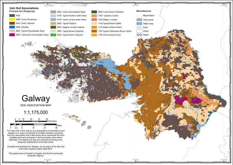
Galway is home to Lough Corrib, which is the largest lake in Ireland, the Twelve Bens mountain range and Connemara, where the patchwork landscape of stone walls is often considered the essence of traditional Ireland. As such, Lough Corrib provides a natural divide, giving rise to two different landscapes to the east and to the west.
To the east, the landscape is generally flat, limestone glacial till lowlands with basin peat and limestone outcrops (exposed rock). These areas are typified by luvisols (downward clay movement), which are considered good agricultural soils due to their higher clay content and their ability to retain nutrients. However, the increased clay in the subsoil can slow down the movement of water through the profile, meaning that these soils can be moderately to poorly draining, depending on the soil texture.
The flatness on the east is broken on the Clare border by the Slieve Aughty Mountains. This area is characterised by wet upland shale hills and glacial drift with sedimentary stones in the lowlands.
To the west of Lough Corrib, the landscape is rugged, mountainous and is overall less fertile. In the northwest, near Letterfrack, upland blanket peat and stagno- podzols are prevalent. The upland blanket peat is commonly cut-over and intermixed with stagno-podzlols. Cut-over refers to the removal of peat by hand-cutting methods but where the remaining peat is sufficiently deep to still be considered a peat soil. Stagno-podzols are found on raised sites but present drainage issues due to a slowly permeable sub-surface layer at depth. To the south, around Spiddal and Rosmuck, the landscape is described as wet undulating shale with glacial drift with sedimentary stones associated with wet soils such as Surface-water Gleys.
Almost half of all soils in Galway are calcareous brown earths. These were formed in calcareous parent material and, while having distinct topsoil, they show a calcareous sub-surface horizon within 40cm. These dominate the area between Galway and Tuam and can be found further east also, but to a lesser extent. Of the calcareous brown earths found here, most are the Faoldroim series (found in association 1150c led by subgroup 1150). These can be described as fine loamy glacial drift with limestone.
Interspersed with these are brown earths, which are the second most prevalent soil type in the county making up one-third of Galway soils. Brown earths are considered a farmer’s friend owing to their free draining nature and good nutrient retention. These are found mostly towards the east around Loughrea. The most readily found brown earth is the Mullabane series (found in association 1100q led by subgroup 1100) and, while also comprised of glacial drift with limestone, these are coarse loamy, indicating a higher sand content with less clay than the Faoldroim series. Other readily found soils include Histic Lithosols, which can be found all along the Galway coast. These are acidic shallow soils, common on mountain landscapes, found here with a peaty surface horizon.


 This is a subscriber-only article


SHARING OPTIONS: