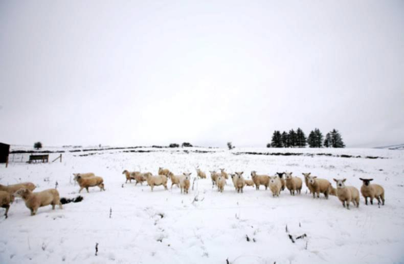
Snow hits County Sligo. Geevagh, Co Sligo.
Photo: Brian Farrell.
ADVERTISEMENT
After heavy snow and rain and gale force winds across the country on Thursday night, Friday will be cold and breezy, with frost and ice in the morning. It will be a mixture of bright spells and showers of rain and hail which will turn wintry on higher ground. Highest temperatures of 4-7C.
Saturday will be another cold and windy day, with bright spells and scattered wintry showers. Temperatures during the day will reach between 4-6C, before dropping to between 0 and -4C Saturday night. Saturday night will be bitterly cold with wintry showers mainly in parts of the west and the north, bringing frost and ice.
Sunday will be dry in many parts, however coastal areas along the west and north of the country will be at risk to further wintry showers. Sunday will be a cold day, with highest temperatures reaching just 3-6C. Sunday night will become very cold and temperatures will drop to between 0 and -5C, with frost and ice.
ADVERTISEMENT
Outlook
Monday looks uncertain, with some rain during the day and temperatures of just 3-5C. The rain is likely to turn to sleet and snow overnight as it spreads eastwards.
The rain sleet and snow will gradually clear away on Tuesday, with the rest of the week expected to remain cold but mostly dry.
Register for free to read this story and our free stories.
This content is available to digital subscribers and loyalty code users only. Sign in to your account, use the code or subscribe to get unlimited access.
The reader loyalty code gives you full access to the site from when you enter it until the following Wednesday at 9pm. Find your unique code on the back page of Irish Country Living every week.
CODE ACCEPTED
You have full access to the site until next Wednesday at 9pm.
CODE NOT VALID
Please try again or contact support.
After heavy snow and rain and gale force winds across the country on Thursday night, Friday will be cold and breezy, with frost and ice in the morning. It will be a mixture of bright spells and showers of rain and hail which will turn wintry on higher ground. Highest temperatures of 4-7C.
Saturday will be another cold and windy day, with bright spells and scattered wintry showers. Temperatures during the day will reach between 4-6C, before dropping to between 0 and -4C Saturday night. Saturday night will be bitterly cold with wintry showers mainly in parts of the west and the north, bringing frost and ice.
Sunday will be dry in many parts, however coastal areas along the west and north of the country will be at risk to further wintry showers. Sunday will be a cold day, with highest temperatures reaching just 3-6C. Sunday night will become very cold and temperatures will drop to between 0 and -5C, with frost and ice.
Outlook
Monday looks uncertain, with some rain during the day and temperatures of just 3-5C. The rain is likely to turn to sleet and snow overnight as it spreads eastwards.
The rain sleet and snow will gradually clear away on Tuesday, with the rest of the week expected to remain cold but mostly dry.
If you would like to speak to a member of our team, please call us on 01-4199525.
Link sent to your email address
We have sent an email to your address. Please click on the link in this email to reset your password. If you can't find it in your inbox, please check your spam folder. If you can't find the email, please call us on 01-4199525.
ENTER YOUR LOYALTY CODE:
The reader loyalty code gives you full access to the site from when you enter it until the following Wednesday at 9pm. Find your unique code on the back page of Irish Country Living every week.


SHARING OPTIONS