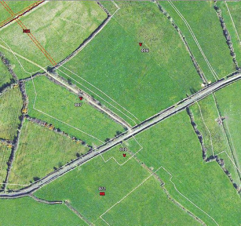
The review of the Land Parcel Identification System (LPIS) will update the existing farm payment maps to the Ordnance survey (OSI) map of Ireland from 2015.
The process is essentially the digitisation of the old OSI 6in maps from 1995 on the Department’s spatial database.
LPIS holds over 1.3 million land parcels for over 130,000 farmers and is the engine that drives payments.
The old maps have positional accuracy issues.
Lower chance of inspection
There is a lower chance of an inspection being triggered when the new maps are in place, according to Department official Deirdre Fay who is managing the LPIS rebuild project.
She was speaking at an information evening for farmers at City North Hotel in Meath last Wednesday.
Real world features
In some cases, there are features on the maps that are out of line with real world features, such as hedgerows.
The new system is expected to fix that.
If the OSI had not included something like a farmyard extension in their database, the Department will cross reference the OSI map with more recent satellite data.

Parcels will be correctly aligned with Real World Features (RWF) in the new system
“We come across a number of house sites on an ongoing basis. We will take the best of LPIS and the satellite data where OSI is not up to date,” Department officials said.
Administrative boundaries
Currently, land parcels with more than one townland are split along the townland line.
However, as land has changed, some hedgerows would have been removed.
So two parcels split by administrative boundaries like these with no real world feature will be merged.

Administrative (townland) boundaries such as the purple line on this map will be removed if they do not correspond to a Real World Feature such as a hedgerow
Where there is a District Electoral Division or townland boundary not reflected on the ground, the boundary will be removed and the old parcel number will void the parcel.
The area will be consumed by the bigger parcel. The area is not lost. However this will impact on payments such as Areas of Natural Constraint where one townland may be on a different rate of payment per hectare to another.
If both townlands are ANC then there is no problem. But if it is at a different rate or the other townland is not designated, the full Maximum Eligible Area of the parcel is calculated and the percentage ANC paid on or different rate is calculated. There may be some slight difference but it won’t affect in the main, Department officials said.
Split parcels
If a roadway or river passes through a parcel, it will be split.
There won’t be a reduction in area if the roadway was taken out correctly in older maps.

In areas where a road or river runs through a land parcel, it will be split into two separate parcels. In this image the blue line is the old mapping system and the white line is the new one. The old parcel here has been split into two, A and B.
If there is an exclusion for scrub, the parcel will not be split, only roads and rivers.
Parcel renumbering
Every time a parcel is updated as a result of an inspection, the parcel gets renumbered.
In the new system, there will be a reduced requirement to change the parcel number.
The old eight-digit number will be replaced by a 10-digit number.
What does this mean for farmers?
Louth is live in new Basic Payment Scheme (BPS) iNet. This includes all parcels declared by Louth-based herd owners and all parcels in Louth.
The Department is advising that farmers examine parcel details carefully to ensure there is an eligible hectare to accompany each entitlement.
You can review the changes as you make your 2019 BPS application.

Changes to your parcels will appear on your BPS like this. It will show the old parcel number and the new one, the new digitised area, the old Maximum Eligible Area and the new Maximum Eligible Area. Farmers affected will receive two sets of maps, the old and new, and are advised to examine them carefully.
Schemes affected include BPS and GLAS. There are certain rules when it comes to the mapping rebuild.
“We are not merging parcels that are in GLAS. That is queued for as soon as GLAS contract expires and will review parcels then,” Department officials said.
“For ANC, you could have a parcel with some ANC and some without because the townland/DED boundaries have been removed. They have rules put in place to make sure correct area is paid on. Organic and forestry schemes also apply.”
Read more
New maps may change BPS claims
The review of the Land Parcel Identification System (LPIS) will update the existing farm payment maps to the Ordnance survey (OSI) map of Ireland from 2015.
The process is essentially the digitisation of the old OSI 6in maps from 1995 on the Department’s spatial database.
LPIS holds over 1.3 million land parcels for over 130,000 farmers and is the engine that drives payments.
The old maps have positional accuracy issues.
Lower chance of inspection
There is a lower chance of an inspection being triggered when the new maps are in place, according to Department official Deirdre Fay who is managing the LPIS rebuild project.
She was speaking at an information evening for farmers at City North Hotel in Meath last Wednesday.
Real world features
In some cases, there are features on the maps that are out of line with real world features, such as hedgerows.
The new system is expected to fix that.
If the OSI had not included something like a farmyard extension in their database, the Department will cross reference the OSI map with more recent satellite data.

Parcels will be correctly aligned with Real World Features (RWF) in the new system
“We come across a number of house sites on an ongoing basis. We will take the best of LPIS and the satellite data where OSI is not up to date,” Department officials said.
Administrative boundaries
Currently, land parcels with more than one townland are split along the townland line.
However, as land has changed, some hedgerows would have been removed.
So two parcels split by administrative boundaries like these with no real world feature will be merged.

Administrative (townland) boundaries such as the purple line on this map will be removed if they do not correspond to a Real World Feature such as a hedgerow
Where there is a District Electoral Division or townland boundary not reflected on the ground, the boundary will be removed and the old parcel number will void the parcel.
The area will be consumed by the bigger parcel. The area is not lost. However this will impact on payments such as Areas of Natural Constraint where one townland may be on a different rate of payment per hectare to another.
If both townlands are ANC then there is no problem. But if it is at a different rate or the other townland is not designated, the full Maximum Eligible Area of the parcel is calculated and the percentage ANC paid on or different rate is calculated. There may be some slight difference but it won’t affect in the main, Department officials said.
Split parcels
If a roadway or river passes through a parcel, it will be split.
There won’t be a reduction in area if the roadway was taken out correctly in older maps.

In areas where a road or river runs through a land parcel, it will be split into two separate parcels. In this image the blue line is the old mapping system and the white line is the new one. The old parcel here has been split into two, A and B.
If there is an exclusion for scrub, the parcel will not be split, only roads and rivers.
Parcel renumbering
Every time a parcel is updated as a result of an inspection, the parcel gets renumbered.
In the new system, there will be a reduced requirement to change the parcel number.
The old eight-digit number will be replaced by a 10-digit number.
What does this mean for farmers?
Louth is live in new Basic Payment Scheme (BPS) iNet. This includes all parcels declared by Louth-based herd owners and all parcels in Louth.
The Department is advising that farmers examine parcel details carefully to ensure there is an eligible hectare to accompany each entitlement.
You can review the changes as you make your 2019 BPS application.

Changes to your parcels will appear on your BPS like this. It will show the old parcel number and the new one, the new digitised area, the old Maximum Eligible Area and the new Maximum Eligible Area. Farmers affected will receive two sets of maps, the old and new, and are advised to examine them carefully.
Schemes affected include BPS and GLAS. There are certain rules when it comes to the mapping rebuild.
“We are not merging parcels that are in GLAS. That is queued for as soon as GLAS contract expires and will review parcels then,” Department officials said.
“For ANC, you could have a parcel with some ANC and some without because the townland/DED boundaries have been removed. They have rules put in place to make sure correct area is paid on. Organic and forestry schemes also apply.”
Read more
New maps may change BPS claims


SHARING OPTIONS