Monday morning is forecast to be mainly dry across the northern half of the country, with mist and fog patches clearing, according to Met Éireann.
Rain is to extend gradually northwards across Munster and south Leinster during the morning, extending further north during the afternoon.
Some heavy falls of rain are forecast in parts of Munster and Leinster, with a risk of spot flooding. Parts of Ulster are set to remain dry until the evening or early night.
Maximum temperatures on Monday will range from 13°C to 17°C, with the highest values in the south.
Outbreaks of rain will affect much of the country on Monday night, with a risk of thunder in the south. There will be lows of 7°C to 11°C in mainly light or moderate northeasterly winds, but it will be fresh and gusty at times near the east coast.
Tuesday
Tuesday is forecast to start out rather damp and cloudy, with patchy rain and drizzle. Brighter, clearer and drier weather will gradually extend from the west and northwest during the morning.
Met Éireann has said it will be rather cool, with maximum temperatures of just 11°C to 15°C, with the highest values in the southwest. Winds will be generally moderate, but fresh and gusty at times near the east coast, northeast to north in direction.
Tuesday night is forecast to be mainly dry, apart from the odd coastal shower in the north. There is a risk of grass frost on Tuesday night, with minimum temperatures dropping to between 2°C and 6°C under clear skies.
Wednesday
Wednesday looks like a dry day countrywide. After a bright, cool and crisp start with thin high cloud, cloud amounts will gradually increase. But Met Éireann said that bright or hazy sunny spells will still occur.
Like Tuesday, it will be another rather cool day, with top temperatures ranging from 11°C to 15°C. Breezes will be mainly light and variable, becoming southeasterly during the afternoon.
Thursday and Friday
Met Éireann has warned that during the end of the week there is potential for unsettled weather to develop. However, uncertainties remain about the track of Hurricane Lorenzo for this time frame. It is likely to become milder due to the influence of tropical origin air, it said. Met Éireann continues to monitor the hurricane.
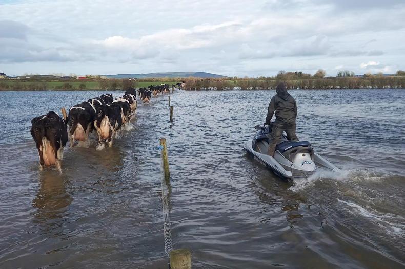
Much of the country experienced far above average rainfall over the last seven days, Met Éireann data shows, with some counties in the midlands experiencing four or five times the average amount (up to 100mm).
For the coming week rainfall totals are likely to be two or three times the average. It said most soils will reach saturation this week, with some moderately or poorly drained soils becoming waterlogged.
Read more
Options for suckled calves - sell now or hold on?
Grain growers call on Glanbia to reconsider 2019 grain prices
Monday morning is forecast to be mainly dry across the northern half of the country, with mist and fog patches clearing, according to Met Éireann.
Rain is to extend gradually northwards across Munster and south Leinster during the morning, extending further north during the afternoon.
Some heavy falls of rain are forecast in parts of Munster and Leinster, with a risk of spot flooding. Parts of Ulster are set to remain dry until the evening or early night.
Maximum temperatures on Monday will range from 13°C to 17°C, with the highest values in the south.
Outbreaks of rain will affect much of the country on Monday night, with a risk of thunder in the south. There will be lows of 7°C to 11°C in mainly light or moderate northeasterly winds, but it will be fresh and gusty at times near the east coast.
Tuesday
Tuesday is forecast to start out rather damp and cloudy, with patchy rain and drizzle. Brighter, clearer and drier weather will gradually extend from the west and northwest during the morning.
Met Éireann has said it will be rather cool, with maximum temperatures of just 11°C to 15°C, with the highest values in the southwest. Winds will be generally moderate, but fresh and gusty at times near the east coast, northeast to north in direction.
Tuesday night is forecast to be mainly dry, apart from the odd coastal shower in the north. There is a risk of grass frost on Tuesday night, with minimum temperatures dropping to between 2°C and 6°C under clear skies.
Wednesday
Wednesday looks like a dry day countrywide. After a bright, cool and crisp start with thin high cloud, cloud amounts will gradually increase. But Met Éireann said that bright or hazy sunny spells will still occur.
Like Tuesday, it will be another rather cool day, with top temperatures ranging from 11°C to 15°C. Breezes will be mainly light and variable, becoming southeasterly during the afternoon.
Thursday and Friday
Met Éireann has warned that during the end of the week there is potential for unsettled weather to develop. However, uncertainties remain about the track of Hurricane Lorenzo for this time frame. It is likely to become milder due to the influence of tropical origin air, it said. Met Éireann continues to monitor the hurricane.
Much of the country experienced far above average rainfall over the last seven days, Met Éireann data shows, with some counties in the midlands experiencing four or five times the average amount (up to 100mm).
For the coming week rainfall totals are likely to be two or three times the average. It said most soils will reach saturation this week, with some moderately or poorly drained soils becoming waterlogged.
Read more
Options for suckled calves - sell now or hold on?
Grain growers call on Glanbia to reconsider 2019 grain prices


SHARING OPTIONS