In a new report titled Finding farming in our placenames, Teagasc researchers Jesko Zimmermann and Rob O’Hara have used Irish placenames to find evidence of past farming activity.
The researchers said: “Placenames provide a window into to how our ancestors viewed and conceptualised their landscape. Our countryside is replete with specific names that recall physical, cultural, historical, or functional characteristics for a location.”
The report states that placenames are frequently Irish names spelt phonetically, often with different characteristics coded into a single name and a reference to agricultural land use.
Mapping the past
Townland placenames were used to map references to farming, including specific arable crops, land measures, land use, and references to pasture and livestock farming.
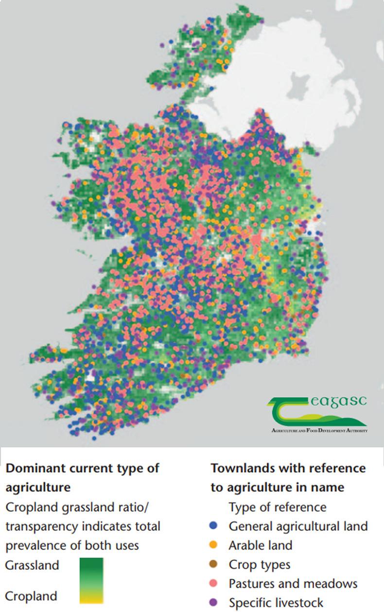
The map shows evidence for mixed farming practices that were more common in previous centuries. Placenames relating to arable farming are intermingled with pastoral placenames, found far outside the current extent of arable farming today.
Pasture and meadows are abundant in the north midlands, Galway and Mayo. Areas of extensive bog or mountain have fewer agricultural names, but they are not completely absent. Summer pasture would have been common in these areas.
The densest concentration of agricultural references is in the midwest region, while in Munster and Leinster there are fewer original placenames relating to farming. References to cropland in the eastern part of the country are uncommon, though this is an area where cropland is now very prevalent.
Forgotten placenames
The report suggests the succession of wars in the 1600s left the country depopulated, resulting in placenames becoming forgotten or renamed by new settlers.
The 1600s also included an attempt by colonisers to legislate against Irish placenames being used, but was largely ignored.
Read more
53% of triplet lambs are sired by different rams
Changing of the guard at Teagasc Authority
In a new report titled Finding farming in our placenames, Teagasc researchers Jesko Zimmermann and Rob O’Hara have used Irish placenames to find evidence of past farming activity.
The researchers said: “Placenames provide a window into to how our ancestors viewed and conceptualised their landscape. Our countryside is replete with specific names that recall physical, cultural, historical, or functional characteristics for a location.”
The report states that placenames are frequently Irish names spelt phonetically, often with different characteristics coded into a single name and a reference to agricultural land use.
Mapping the past
Townland placenames were used to map references to farming, including specific arable crops, land measures, land use, and references to pasture and livestock farming.
The map shows evidence for mixed farming practices that were more common in previous centuries. Placenames relating to arable farming are intermingled with pastoral placenames, found far outside the current extent of arable farming today.
Pasture and meadows are abundant in the north midlands, Galway and Mayo. Areas of extensive bog or mountain have fewer agricultural names, but they are not completely absent. Summer pasture would have been common in these areas.
The densest concentration of agricultural references is in the midwest region, while in Munster and Leinster there are fewer original placenames relating to farming. References to cropland in the eastern part of the country are uncommon, though this is an area where cropland is now very prevalent.
Forgotten placenames
The report suggests the succession of wars in the 1600s left the country depopulated, resulting in placenames becoming forgotten or renamed by new settlers.
The 1600s also included an attempt by colonisers to legislate against Irish placenames being used, but was largely ignored.
Read more
53% of triplet lambs are sired by different rams
Changing of the guard at Teagasc Authority


SHARING OPTIONS