The Met Éireann weather forecast for the weekend has predicted patchy and changeable weather across the country, but with the threat of high impact weather on Monday when the tail end of Hurricane Ophelia will reach Ireland.
The threat of Hurriane Ophelia and the impending slurry deadline on 15 October mean that this weekend could be the last chance for many farmers to spread their slurry.
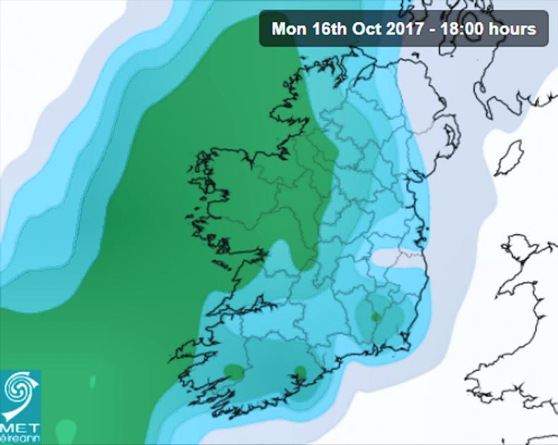
Source: Met Éireann.
It is expected to be mild and cloudy on Friday with occasional outbreaks of rain and drizzle. The weather over Connacht and Ulster will be mostly dry with patchy showers of rain across the country.
Temperatures on Saturday will be between 16-20°C with a cloudy start to the day, and occasional patches of rain across the country, but mostly on the north and west coasts.
On Sunday there will be prolonged periods of heavy and persistent rainfall in parts of Connacht, west Ulster and west Munster.
The rest of the country will experience patchy rainfall with mist and fog persistent in hilly and coastal areas in the southern, western and northwest coasts. However, temperatures will be mild at between 16-19°C
Met Éireann predicts that by Monday the remnants of Hurricane Ophelia will reach Ireland, leading to storm force winds, outbreaks of very heavy rain and high seas.
Read more
’High impact’ Hurrican Ophelia on track to hit Ireland
What to do when exporting slurry
No slurry deadline extension
The Met Éireann weather forecast for the weekend has predicted patchy and changeable weather across the country, but with the threat of high impact weather on Monday when the tail end of Hurricane Ophelia will reach Ireland.
The threat of Hurriane Ophelia and the impending slurry deadline on 15 October mean that this weekend could be the last chance for many farmers to spread their slurry.
Source: Met Éireann.
It is expected to be mild and cloudy on Friday with occasional outbreaks of rain and drizzle. The weather over Connacht and Ulster will be mostly dry with patchy showers of rain across the country.
Temperatures on Saturday will be between 16-20°C with a cloudy start to the day, and occasional patches of rain across the country, but mostly on the north and west coasts.
On Sunday there will be prolonged periods of heavy and persistent rainfall in parts of Connacht, west Ulster and west Munster.
The rest of the country will experience patchy rainfall with mist and fog persistent in hilly and coastal areas in the southern, western and northwest coasts. However, temperatures will be mild at between 16-19°C
Met Éireann predicts that by Monday the remnants of Hurricane Ophelia will reach Ireland, leading to storm force winds, outbreaks of very heavy rain and high seas.
Read more
’High impact’ Hurrican Ophelia on track to hit Ireland
What to do when exporting slurry
No slurry deadline extension


SHARING OPTIONS