For many farmers, the summer of 2018 is one they would rather forget. The drought that led to a fodder crisis is still not far enough in the past for many. However, as the old saying goes, “It’s an ill wind that doesn’t blow some good”.
For journalist, author and researcher Anthony Murphy, who has a lifelong interest in ancient archaeology and mythology, the drought was the catalyst for a once-in-a-lifetime discovery in the Boyne Valley.
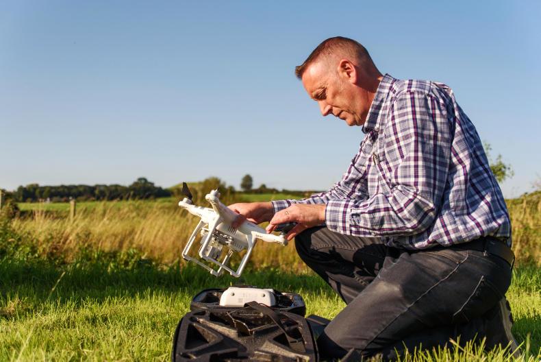
Anthony Murphy with his drone.
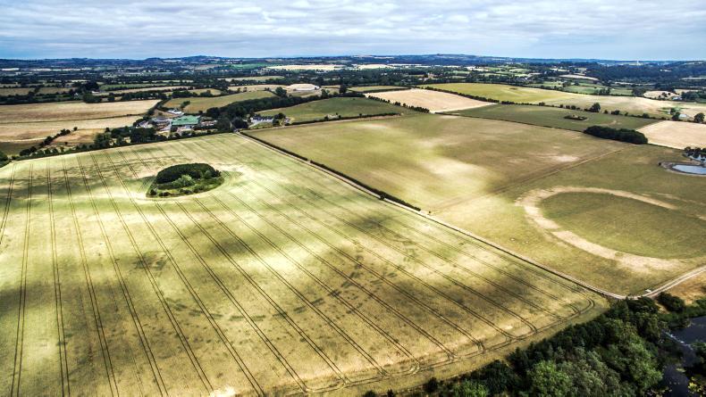
Flying his drone on the evening of Tuesday 10 July, after 10 weeks of virtually no rainfall in the Boyne Valley area, from the aerial footage Anthony found a new henge in one of the fields planted with wheat on Newgrange Farm.
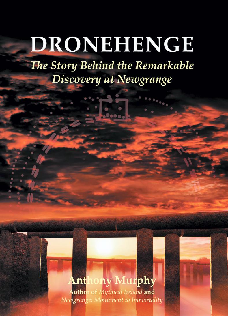
Normally this feature wouldn’t be visible, but the drought caused crop marks, which indicated an archaeological feature underneath. The story of this discovery is detailed in Anthony’s new book Dronehenge, which includes his own original pictures and 3D models of Dronehenge’s possible appearance.
There’s a simple explanation as to why this occurred. If you dig a hole in the ground – in this instance a trench or pit – and over time it’s filled in with organic material, that soil has a different composition and nutrient make-up to the rest.
The fact the soil is looser means crop roots can penetrate it more easily, accessing more moisture and nutrients. Therefore in times of drought, the crop planted on that soil is a stronger colour than the rest.
And thus, “Dronehenge” as it came to be known, stuck out like a sore thumb to Anthony.
“I’ve spent 20 years studying Brú na Bóinne (the Boyne Valley tombs – a UNESCO World Heritage Site), you know where all the known monuments are, you know where they’re not supposed to be. Initially when I saw it, I didn’t believe what I was seeing. I was trying to rationalise it.
“Just for a few brief moments I was wondering did a tractor drive around in a circle in that field. Then I thought, ‘Is this one of those fake crop circles people create?’ I thought for a second, ‘Had there been a circus big top pitched there?’
“That’s all within five or 10 seconds and I’m moving the drone towards it, getting a better picture and seeing more detail.”
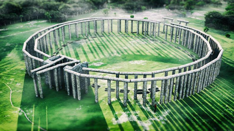
3D model of what Dronehenge may have looked like.
That evening Anthony was flying drones with his photographer friend Ken Williams.
“I think within a minute I realised and Ken realised, this could only be one type of monument, which is a henge. This makes it very exciting.
“Henges were big arenas for something; rituals, games, sports, trade. In the henges with earthen banks, it’s thought people watched from there. In the case of Dronehenge with the post holes, they most likely supported wooden timbers, maybe tiered seating.”
Having made the discovery, Anthony and Ken confirmed their suspicions as to what the monument was and its significance with an archaeologist.
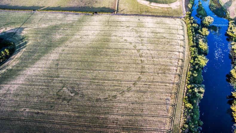
Dronehenge. \ Anthony Murphy
They then posed their discovery on Anthony’s Facebook page Mythical Ireland. The whole thing went viral and there was huge media interest in the discovery.
Since, Anthony has found even more monuments in the area as a result of crop markings caused by the drought. Both Google Satellite and Apple Maps updated their images of the area from the summer of 2018 and hundreds of more discoveries were made.
Towards the end of November Anthony had the honour of speaking at Princeton University in the US about his discovery. Clearly these findings are a massive step forward for Brú na Bóinne, but Anthony still wants to know more about the lives of these ancient people. He hopes that future excavations will enlighten us further.
For more, visit the Mythical Ireland website.
Read more
Ancient farms revealed by drought and satellites
‘Once in a generation’ – Farmers Journal subeditor makes ancient discovery
For many farmers, the summer of 2018 is one they would rather forget. The drought that led to a fodder crisis is still not far enough in the past for many. However, as the old saying goes, “It’s an ill wind that doesn’t blow some good”.
For journalist, author and researcher Anthony Murphy, who has a lifelong interest in ancient archaeology and mythology, the drought was the catalyst for a once-in-a-lifetime discovery in the Boyne Valley.
Anthony Murphy with his drone.
Flying his drone on the evening of Tuesday 10 July, after 10 weeks of virtually no rainfall in the Boyne Valley area, from the aerial footage Anthony found a new henge in one of the fields planted with wheat on Newgrange Farm.
Normally this feature wouldn’t be visible, but the drought caused crop marks, which indicated an archaeological feature underneath. The story of this discovery is detailed in Anthony’s new book Dronehenge, which includes his own original pictures and 3D models of Dronehenge’s possible appearance.
There’s a simple explanation as to why this occurred. If you dig a hole in the ground – in this instance a trench or pit – and over time it’s filled in with organic material, that soil has a different composition and nutrient make-up to the rest.
The fact the soil is looser means crop roots can penetrate it more easily, accessing more moisture and nutrients. Therefore in times of drought, the crop planted on that soil is a stronger colour than the rest.
And thus, “Dronehenge” as it came to be known, stuck out like a sore thumb to Anthony.
“I’ve spent 20 years studying Brú na Bóinne (the Boyne Valley tombs – a UNESCO World Heritage Site), you know where all the known monuments are, you know where they’re not supposed to be. Initially when I saw it, I didn’t believe what I was seeing. I was trying to rationalise it.
“Just for a few brief moments I was wondering did a tractor drive around in a circle in that field. Then I thought, ‘Is this one of those fake crop circles people create?’ I thought for a second, ‘Had there been a circus big top pitched there?’
“That’s all within five or 10 seconds and I’m moving the drone towards it, getting a better picture and seeing more detail.”
3D model of what Dronehenge may have looked like.
That evening Anthony was flying drones with his photographer friend Ken Williams.
“I think within a minute I realised and Ken realised, this could only be one type of monument, which is a henge. This makes it very exciting.
“Henges were big arenas for something; rituals, games, sports, trade. In the henges with earthen banks, it’s thought people watched from there. In the case of Dronehenge with the post holes, they most likely supported wooden timbers, maybe tiered seating.”
Having made the discovery, Anthony and Ken confirmed their suspicions as to what the monument was and its significance with an archaeologist.
Dronehenge. \ Anthony Murphy
They then posed their discovery on Anthony’s Facebook page Mythical Ireland. The whole thing went viral and there was huge media interest in the discovery.
Since, Anthony has found even more monuments in the area as a result of crop markings caused by the drought. Both Google Satellite and Apple Maps updated their images of the area from the summer of 2018 and hundreds of more discoveries were made.
Towards the end of November Anthony had the honour of speaking at Princeton University in the US about his discovery. Clearly these findings are a massive step forward for Brú na Bóinne, but Anthony still wants to know more about the lives of these ancient people. He hopes that future excavations will enlighten us further.
For more, visit the Mythical Ireland website.
Read more
Ancient farms revealed by drought and satellites
‘Once in a generation’ – Farmers Journal subeditor makes ancient discovery


SHARING OPTIONS