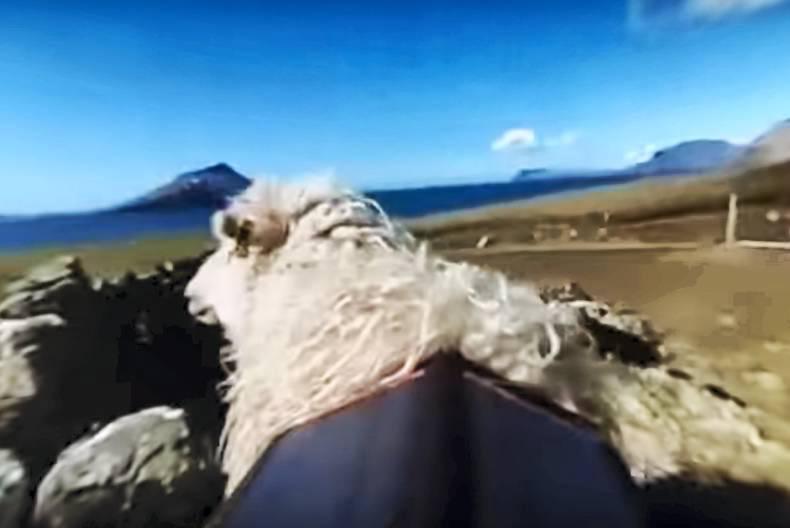
One of Durita Dahl Andreassen's sheep filming the scenery in the Faroe Islands. Photo: Screenshot from video
ADVERTISEMENT
The group of volcanic islands lies half way between Scotland and Iceland and was never visited by Street View, the online service offered by Google to navigate maps as if walking down a country's streets.
"Taking matters into my own hands, I decided to create my own version of Street View – Sheep View 360," Andreassen wrote on her blog this Monday.
Although some areas on the Faroe Islands are not accessible by car, there are plenty of sheep around – twice as many as inhabitants, according to Andreassen.
ADVERTISEMENT
"I gently placed a 360° camera, powered by a solar panel, on the back of a sheep that would take photographs as the animal freely grazed the open hillsides of the Faroe Islands," Andreassen explained. "Photos are then transmitted back to my mobile phone so that I can upload them to Google Street View myself, finally putting the Faroes on the map in a very unique way!"
This Tuesday, she released the first 360° video filmed by sheep. Watch it below, using the arrows to rotate the viewing direction:
Andreassen's next challenge is to find out how to get the camera back from the sheep – and to gather enough signatures on a petition to convince Google to visit the Faroe Islands and complete the mapping exercise.
Register for free to read this story and our free stories.
This content is available to digital subscribers and loyalty code users only. Sign in to your account, use the code or subscribe to get unlimited access.
The reader loyalty code gives you full access to the site from when you enter it until the following Wednesday at 9pm. Find your unique code on the back page of Irish Country Living every week.
CODE ACCEPTED
You have full access to the site until next Wednesday at 9pm.
CODE NOT VALID
Please try again or contact support.
The group of volcanic islands lies half way between Scotland and Iceland and was never visited by Street View, the online service offered by Google to navigate maps as if walking down a country's streets.
"Taking matters into my own hands, I decided to create my own version of Street View – Sheep View 360," Andreassen wrote on her blog this Monday.
Although some areas on the Faroe Islands are not accessible by car, there are plenty of sheep around – twice as many as inhabitants, according to Andreassen.
"I gently placed a 360° camera, powered by a solar panel, on the back of a sheep that would take photographs as the animal freely grazed the open hillsides of the Faroe Islands," Andreassen explained. "Photos are then transmitted back to my mobile phone so that I can upload them to Google Street View myself, finally putting the Faroes on the map in a very unique way!"
This Tuesday, she released the first 360° video filmed by sheep. Watch it below, using the arrows to rotate the viewing direction:
Andreassen's next challenge is to find out how to get the camera back from the sheep – and to gather enough signatures on a petition to convince Google to visit the Faroe Islands and complete the mapping exercise.
If you would like to speak to a member of our team, please call us on 01-4199525.
Link sent to your email address
We have sent an email to your address. Please click on the link in this email to reset your password. If you can't find it in your inbox, please check your spam folder. If you can't find the email, please call us on 01-4199525.
ENTER YOUR LOYALTY CODE:
The reader loyalty code gives you full access to the site from when you enter it until the following Wednesday at 9pm. Find your unique code on the back page of Irish Country Living every week.


SHARING OPTIONS