Ireland and Britain can expect an increase in stormy winter weather in the years ahead, University of Reading Professor of Climate Science Len Shaffrey has warned.
A warmer atmosphere is able to hold more moisture and produce more extreme rainfall, he told the Met Éireann conference The Wind that Shakes the Island in the RDS last Friday.
“In a warmer climate, one of the things we expect is that the atmosphere will be able to hold more moisture. For every degree the atmosphere gets warmer we expect moisture, and therefore extreme rainfall, to go up by 7%.”
He added that climate models show an increase of 20% to 25% in rain produced in heavily precipitating storms.
“That’s very consistent with this idea that the atmosphere is just getting warmer,” he said.
Extreme weather events such as Hurricane Ophelia have been witnessed in Ireland this past winter. Luckily, most of the rainfall associated with it fell off the west coast of the country.
But, typically speaking, hurricanes bring high levels of rainfall in the days afterwards. Examples include the 3ft of rain that fell across hundreds of miles of the US after Hurricane Harvey, and in Texas, where huge floods were recorded in August and September 2017.
Hurricane Ophelia was the most eastern hurricane on record. Just before it hit Ireland, the colder waters below and the westerly winds above were tearing the tropical cyclone apart. It was officially “post-tropical” when it made landfall in Ireland on Monday 16 October.
Can we expect more of these in Ireland?
“Science has not answered this question yet, but computing power is increasing all the time and people are pushing up the resolution of climate models,” Prof Shaffrey said.
“There is an increase in extra tropical transitions hitting, due to tropical cyclones being supported further north and eastward according to some climate models.”
Storm Emma’s snow was also down to an increase in moisture in the air.
“It’s sort of counter-intuitive that as the climate gets warmer that we would get more snowfall,” said Evelyn Cusack, Met Éireann’s head of forecasting.
“If there is more moisture in the air, there is more precipitation. If that meets more cold air, then you get more snow, which is actually what happened in Ireland – as the warm front associated with Storm Emma came up, it hit the Siberian air. So we got very heavy snow even though the climate is getting warmer.”
Storm Emma
Valentia Observatory experienced its coldest March since 1962 this year. Its highest mean temperature for the month was 5.7°C.The lowest air temperature reported was -7°C at Cork airport, its lowest March temperature since 1962.The lowest ground temperature was -13.2°C in Markree, Co Sligo, its lowest March temperature since 2013.
Hurricane Ophelia
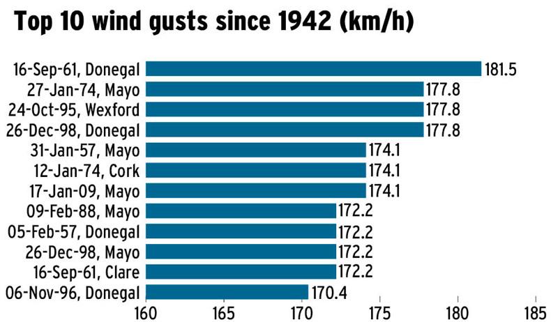
Roches Point in Co Cork experienced October 2017’s highest gust (155.6km/h) and the highest 10-minute mean wind speed (114.8km/h). These were the highest on record at Roches Point. Read more
Grass growth falls to 2013 levels
Irish winters are getting wetter
Cost of Storm Emma to run into tens of millions
Ireland and Britain can expect an increase in stormy winter weather in the years ahead, University of Reading Professor of Climate Science Len Shaffrey has warned.
A warmer atmosphere is able to hold more moisture and produce more extreme rainfall, he told the Met Éireann conference The Wind that Shakes the Island in the RDS last Friday.
“In a warmer climate, one of the things we expect is that the atmosphere will be able to hold more moisture. For every degree the atmosphere gets warmer we expect moisture, and therefore extreme rainfall, to go up by 7%.”
He added that climate models show an increase of 20% to 25% in rain produced in heavily precipitating storms.

“That’s very consistent with this idea that the atmosphere is just getting warmer,” he said.
Extreme weather events such as Hurricane Ophelia have been witnessed in Ireland this past winter. Luckily, most of the rainfall associated with it fell off the west coast of the country.
But, typically speaking, hurricanes bring high levels of rainfall in the days afterwards. Examples include the 3ft of rain that fell across hundreds of miles of the US after Hurricane Harvey, and in Texas, where huge floods were recorded in August and September 2017.
Hurricane Ophelia was the most eastern hurricane on record. Just before it hit Ireland, the colder waters below and the westerly winds above were tearing the tropical cyclone apart. It was officially “post-tropical” when it made landfall in Ireland on Monday 16 October.
Can we expect more of these in Ireland?
“Science has not answered this question yet, but computing power is increasing all the time and people are pushing up the resolution of climate models,” Prof Shaffrey said.
“There is an increase in extra tropical transitions hitting, due to tropical cyclones being supported further north and eastward according to some climate models.”
Storm Emma’s snow was also down to an increase in moisture in the air.
“It’s sort of counter-intuitive that as the climate gets warmer that we would get more snowfall,” said Evelyn Cusack, Met Éireann’s head of forecasting.
“If there is more moisture in the air, there is more precipitation. If that meets more cold air, then you get more snow, which is actually what happened in Ireland – as the warm front associated with Storm Emma came up, it hit the Siberian air. So we got very heavy snow even though the climate is getting warmer.”
Storm Emma
Valentia Observatory experienced its coldest March since 1962 this year. Its highest mean temperature for the month was 5.7°C.The lowest air temperature reported was -7°C at Cork airport, its lowest March temperature since 1962.The lowest ground temperature was -13.2°C in Markree, Co Sligo, its lowest March temperature since 2013.
Hurricane Ophelia
Roches Point in Co Cork experienced October 2017’s highest gust (155.6km/h) and the highest 10-minute mean wind speed (114.8km/h). These were the highest on record at Roches Point. Read more
Grass growth falls to 2013 levels
Irish winters are getting wetter
Cost of Storm Emma to run into tens of millions





SHARING OPTIONS