The severity of Hurricane Ophelia had dawned on most of us not long before we were forced inside as unusually high winds raged; pulling down trees, tearing roofs off sheds and damaging power lines. However at the Met Eireann office, over a week beforehand forecasters were busy trying to analyse what the weather system moving over the Atlantic was going to bring to our island.
“I remember thinking ‘I don’t like the look of Monday at all’,” said Liz Walsh, a forecaster on the desk in the week running up to Monday, 16 October 2017, when Hurricane Ophelia made landfall.
Listen to "Forecasting Hurricane Ophelia" on Spreaker.
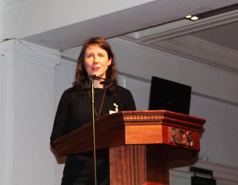
Liz Walsh, Met Eireann, speaking at RDS conference.Ophelia started off west of the Azures in early October as a low pressure system with fronts. It moved down to where sea temperatures were abnormally tropical.
“You can tell the temperature of the storm by the shades of grey and white in the satellite image,” said Walsh. “The ECMWF forecast on Wednesday, 10 October, was unnerving. It showed a wind event was possible for the whole of Ireland on 16 October.”
ECMWF is the European Centre for Medium-Range Weather Forecasts and Met Eireann uses it for 10-day forecasts. Head of forecasting in Met Eireann, Evelyn Cusack, describes it as a “large computer that carries out two quadrillion calculations per second”.
By Wednesday it had officially been named as a hurricane and its track had shifted from Portugal to Ireland. The Portugese Met Office had named it Ophelia. The first country to issue a weather warning names the storm.
“The duty forecaster in Exeter rang Dublin and said ‘Hey what’s up, maybe we should talk about what we are going to do on Monday’. But at this stage there is still an enormous amount of uncertainty,” said Walsh. “We don’t know the intensity of Ophelia and she is in a very odd place, the northeastern Atlantic. They don’t happen that often there; the sea temperatures are borderline. Is the intensity going to get bigger? That information is crucial for the forecast we give on highest windspeeds and rainfall.”
Ophelia had started to track northeastwards. The National Hurricane Centre in Florida, the UK Met Office and Met Eireann started having joint phonecalls to co-ordinate key messages for when the national met offices took over the forecasting from the Hurricane Centre. It issues advisory every six hours to met offices which then forecast the local impact of the hurricane.
A note issued from the NHC in Florida at 11PM Atlantic Standard Time (AST) stated; “Remarkably, the hurricane has continued to strengthen this evening. Satellite images indicate that cloud tops in the eyewall have cooled in the past several hours, with a warm eye remaining."
Ophelia had reached category two hurricane status. Category five is the strongest and it is based on peak wind speed. Wind speeds when it made landfall were expected to reach 157km/hr to 166km/hr and the eye of the storm was visible.
Met Eireann issued a warning for storm-force winds.
Friday and Saturday, 13-14 October
Hurricane Ophelia photographed in the Atlantic on Saturday.
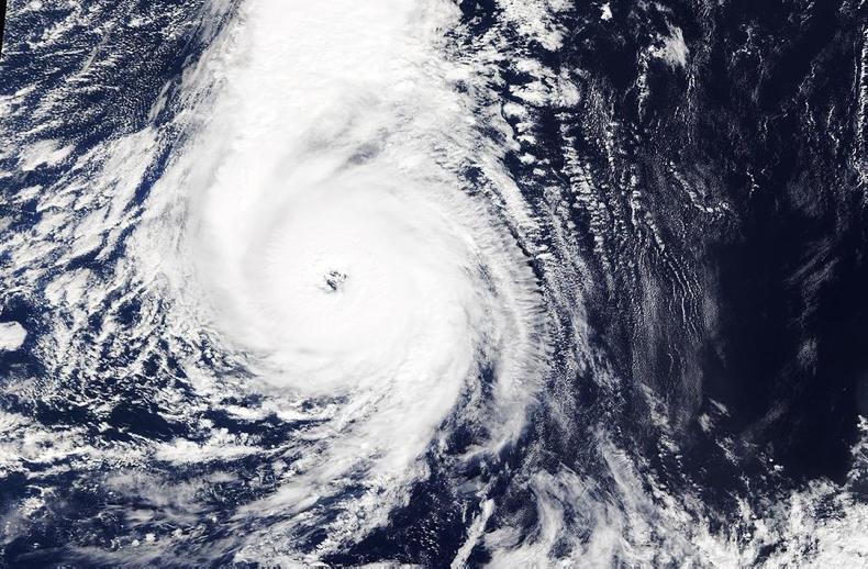
Hurricane Ophelia photographed over the Atlantic. \ Met Éireann/Twitter“On Friday it weakened a bit, which is normal for a tropical cyclone,” said Walsh. “By Saturday it had strengthened to category three. It had a larger eye and there was a good bit of water in the satellite image.”
The high resolution model, which works 52 hours ahead, was showing mean wind speeds of 120km/hr, meaning that gusts would be even stronger than that.
Met Eireann issued a red warning for the west of Ireland.
By Sunday Ophelia was accelerating towards western Europe. It also sped up as it headed into strong upper level westerly winds. It was also moving over colder waters, meaning it was losing intensity from the bottom as well.
“Because it was moving so fast it was still going to retain hurricane force winds. The eye had filled in and westerly winds were tearing the top away. Transitioning cyclones split with rain on one side and winds on the other,” said Walsh.
A red warning for the entire country was issued that evening.
The storm became post-tropical and made landfall. The heavy rainfall fell off the west coast of Ireland and the highest gust speed recorded was 156km/hr.
Ophelia spent its entire time as a hurricane over the northeastern Atlantic. However, it still brought hurricane force wind gusts to Ireland and parts of the UK.
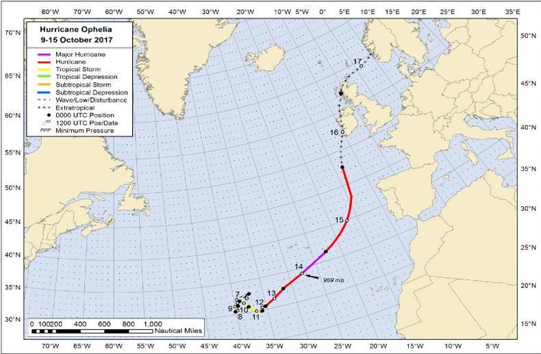
Best track positions for Hurricane Ophelia, 9-15 October 2017. The track during the extratropical stage on 16-17 October is partially based on analysis from the NOAA Ocean Prediction Center, Met Eireann and the UKMET.Best track positions for Hurricane Ophelia, 9-15 October 2017. The track during the extratropical stage on 16-17 October is partially based on analysis from the NOAA Ocean Prediction Center, Met Eireann and the UKMET.
The NHC report reads: “The Kinsale Energy natural gas platform, located off-shore of the southern coast of Ireland in the Celtic Sea, reported a record individual wave height of at least 85ft (26.1m). The previous record at the platform had been 82ft (25 m) set in 2014. (...) There were no reports of casualties associated with Ophelia while it was a tropical cyclone. However, three deaths occurred in Ireland during Ophelia’s extratropical phase.”
Read more
Full coverage: Ophelia
Extreme rain and winter storms to increase
The severity of Hurricane Ophelia had dawned on most of us not long before we were forced inside as unusually high winds raged; pulling down trees, tearing roofs off sheds and damaging power lines. However at the Met Eireann office, over a week beforehand forecasters were busy trying to analyse what the weather system moving over the Atlantic was going to bring to our island.
“I remember thinking ‘I don’t like the look of Monday at all’,” said Liz Walsh, a forecaster on the desk in the week running up to Monday, 16 October 2017, when Hurricane Ophelia made landfall.
Listen to "Forecasting Hurricane Ophelia" on Spreaker.
Liz Walsh, Met Eireann, speaking at RDS conference.Ophelia started off west of the Azures in early October as a low pressure system with fronts. It moved down to where sea temperatures were abnormally tropical.
“You can tell the temperature of the storm by the shades of grey and white in the satellite image,” said Walsh. “The ECMWF forecast on Wednesday, 10 October, was unnerving. It showed a wind event was possible for the whole of Ireland on 16 October.”
ECMWF is the European Centre for Medium-Range Weather Forecasts and Met Eireann uses it for 10-day forecasts. Head of forecasting in Met Eireann, Evelyn Cusack, describes it as a “large computer that carries out two quadrillion calculations per second”.
By Wednesday it had officially been named as a hurricane and its track had shifted from Portugal to Ireland. The Portugese Met Office had named it Ophelia. The first country to issue a weather warning names the storm.
“The duty forecaster in Exeter rang Dublin and said ‘Hey what’s up, maybe we should talk about what we are going to do on Monday’. But at this stage there is still an enormous amount of uncertainty,” said Walsh. “We don’t know the intensity of Ophelia and she is in a very odd place, the northeastern Atlantic. They don’t happen that often there; the sea temperatures are borderline. Is the intensity going to get bigger? That information is crucial for the forecast we give on highest windspeeds and rainfall.”
Ophelia had started to track northeastwards. The National Hurricane Centre in Florida, the UK Met Office and Met Eireann started having joint phonecalls to co-ordinate key messages for when the national met offices took over the forecasting from the Hurricane Centre. It issues advisory every six hours to met offices which then forecast the local impact of the hurricane.
A note issued from the NHC in Florida at 11PM Atlantic Standard Time (AST) stated; “Remarkably, the hurricane has continued to strengthen this evening. Satellite images indicate that cloud tops in the eyewall have cooled in the past several hours, with a warm eye remaining."
Ophelia had reached category two hurricane status. Category five is the strongest and it is based on peak wind speed. Wind speeds when it made landfall were expected to reach 157km/hr to 166km/hr and the eye of the storm was visible.
Met Eireann issued a warning for storm-force winds.
Friday and Saturday, 13-14 October
Hurricane Ophelia photographed in the Atlantic on Saturday.
Hurricane Ophelia photographed over the Atlantic. \ Met Éireann/Twitter“On Friday it weakened a bit, which is normal for a tropical cyclone,” said Walsh. “By Saturday it had strengthened to category three. It had a larger eye and there was a good bit of water in the satellite image.”
The high resolution model, which works 52 hours ahead, was showing mean wind speeds of 120km/hr, meaning that gusts would be even stronger than that.
Met Eireann issued a red warning for the west of Ireland.
By Sunday Ophelia was accelerating towards western Europe. It also sped up as it headed into strong upper level westerly winds. It was also moving over colder waters, meaning it was losing intensity from the bottom as well.
“Because it was moving so fast it was still going to retain hurricane force winds. The eye had filled in and westerly winds were tearing the top away. Transitioning cyclones split with rain on one side and winds on the other,” said Walsh.
A red warning for the entire country was issued that evening.
The storm became post-tropical and made landfall. The heavy rainfall fell off the west coast of Ireland and the highest gust speed recorded was 156km/hr.
Ophelia spent its entire time as a hurricane over the northeastern Atlantic. However, it still brought hurricane force wind gusts to Ireland and parts of the UK.
Best track positions for Hurricane Ophelia, 9-15 October 2017. The track during the extratropical stage on 16-17 October is partially based on analysis from the NOAA Ocean Prediction Center, Met Eireann and the UKMET.Best track positions for Hurricane Ophelia, 9-15 October 2017. The track during the extratropical stage on 16-17 October is partially based on analysis from the NOAA Ocean Prediction Center, Met Eireann and the UKMET.
The NHC report reads: “The Kinsale Energy natural gas platform, located off-shore of the southern coast of Ireland in the Celtic Sea, reported a record individual wave height of at least 85ft (26.1m). The previous record at the platform had been 82ft (25 m) set in 2014. (...) There were no reports of casualties associated with Ophelia while it was a tropical cyclone. However, three deaths occurred in Ireland during Ophelia’s extratropical phase.”
Read more
Full coverage: Ophelia
Extreme rain and winter storms to increase


SHARING OPTIONS