

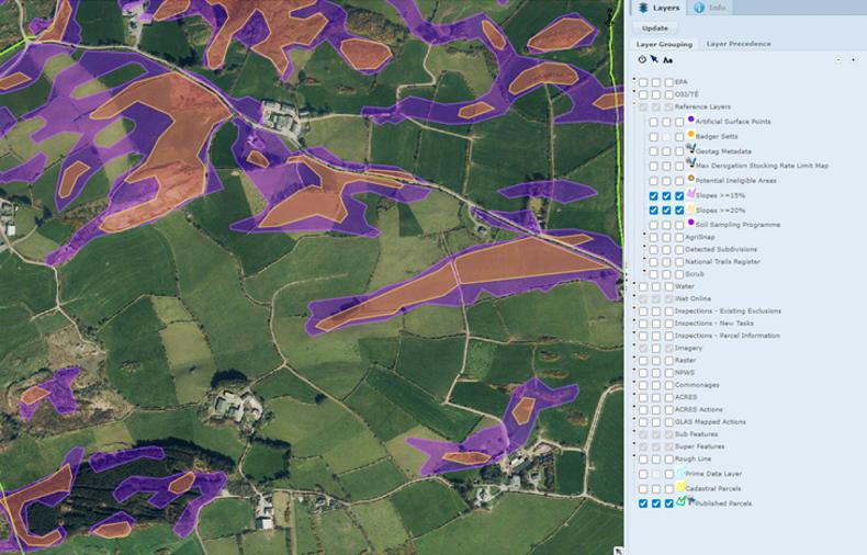
The Department of Agriculture has published the final map which will be used to implement the cut in maximum stocking rates on most derogation farms from 2024.
The map outlines in purple which areas will face a maximum derogation stocking rate reduction to 220kg organic nitrogen/ha from 1 January.
A detailed map is published online, allowing farmers to drill down on a farm-by-farm or field-by-field basis to determine how much, if any, of their land will be impacted.
Adjustments
The updated map appears to show some minor adjustments from a previous derogation ‘red map’ map published by the Environmental Protection Agency (EPA) in June as part of the review of derogation stocking rate limits.
Some relatively small areas within counties, which include Wicklow, Kildare, Donegal, Galway, Clare and Tipperary, appear to have been removed from the area previously marked on the EPA’s map as set to fall to 220kg N/ha.
However, there are no significant changes apparent on a county, or national, basis. Another map, seen earlier this week by the Irish Farmers Journal, had suggested that parts of Clare, Limerick and Donegal would be included in the cut. These areas will instead remain at 250kg.
Any land parcel that is marked only partly in purple will remain at 250kg N/ha, but farmers with parcels in both the 220kg N/ha and 250kg N/ha zones will have to reduce overall stocking rates based on a parcel-by-parcel calculation.
The Irish Farmers Journal understands that 6% fewer farmers (around 230 farmers) will be impacted by the stocking rate change than had been anticipated after the EPA published its ‘red map’ in the summer.
However, exactly how many farmers are impacted is still unknown. The Department has said that between 3,000 and 4,000 derogation farmers are stocked above 220kg N/ha, but this figure is representative of the whole country and the impacts of new cow-banding could also affect this estimate.


SHARING OPTIONS