

A status yellow rainfall warning remains in place for Cork and Kerry for today, 3 January. Rainfall totals of 25 to 40 mm are expected in the space of 24 hours, due to a band of persistent rain followed by scattered heavy showers, highest values over mountains in the west.
Weather forecast
According to Met Eireann the weather will remain changeable and unsettled, with rain or showers each day. The heaviest of the rain is likely to be during Wednesday and Wednesday night. Cool enough at night for some frost, especially Tuesday night.
There will be a few clear spells on Monday night, but generally cloudy and misty with some showers. Some of these could be heavy and prolonged. Some patches of fog forming also. Lowest temperatures 2 to 6 C.
Rain in Ulster will clear north in the PM.Scattered showers elsewhere,heaviest in the south & west.Fog patches soon after dark.Highs 7-11C
— Met Éireann (@MetEireann) January 3, 2016Tuesday will be a cool, fresh day, with some further showers at times. Rather cloudy overall, but a few bright or short sunny spells at times too. Top temperatures 6 to 9 C., in a fresh northwest breeze. Cold after dark, with skies largely clearing and showers becoming well scattered. Lowest temperatures -1 to plus 2 C., with a widespread frost and some icy roads.
Wednesday will be mainly dry, bright, but with a frosty start and slack winds. Some early periods of sunshine, but cloud soon increasing and wet and windy weather will move in off the Atlantic later in the morning and will become widespread by nightfall. The rain will be heavy and is likely to continue for much of the night. So some further flooding is likely. Fresh to strong and gusty south to southeasterly winds will accompany the rain. Top temperatures 5 to 10 C., best along the south coast. Cool overnight with a risk of some frost by dawn Thursday. Lowest temperatures 2 to 5 C.
Thursday and Friday look like being cool, breezy, showery days, with some heavy showers at times. Winds will be mainly fresh and gusty southwesterly.
Road flooded on Ballymacarberry side of Kilmanahan on R672, Co. Waterford.(Spot flooding on many roads nationwide) pic.twitter.com/bLFhnhZuic
— An Garda Síochána (@GardaTraffic) January 3, 2016#StormFrank flooding Armagh. Aerial footage by @Ireland_Aerial. Full video here https://t.co/SnpdW1sYkS… pic.twitter.com/GLvSxfeZvr
— Barra Best (@barrabest) December 30, 2015Level of water flow
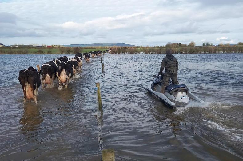
Over the last number of weeks there has been very heavy rainfall in the River Liffey catchment. During these events, a high proportion of the water falling in the upper Liffey has been stored in Pollaphuca reservoir, which has greatly reduced the impact of the flooding downstream.
ESB advises that, due to increased levels at Pollaphuca and ongoing heavy rainfall, it has been necessary to increase discharges of water from the reservoir into the River Liffey. Discharges are currently at approximately 40 cubic metres per second (cumecs).
The additional discharges and natural inflows from any further rainfall into the middle Liffey will lead to an increased risk of flooding in all areas of the middle Liffey, in particular Kilcullen, Clane, Newbridge, Straffan and Celbridge.
Similarly in the Lee catchment, flows from Inniscarra Dam remain at 250 cumecs (cubic metres per second). The ESB say that based on the rain forecast for the coming days, this may need increase above 250 cumecs which will continue to lead to flooding downstream from the Inniscarra Dam.
ESB advises that the flow of water through Parteen Weir will remain at 470 cumecs (cubic metres per second) today, Sunday 3 January.
The levels in Lough Derg may reach 2009 levels in the coming days and, as a result, the flow through Parteen Weir may increase to those levels (up to 500 cumecs). Following Storm Desmond flow of water through Parteen Weir down the old River Shannon was at 440 cumecs.
This level of water flow will have increased associated flooding to land and property in the vicinity of the Shannon downstream of Parteen Weir including the areas of Springfield, Montpelier, Castleconnell, Mountshannon (Annacotty) and the University of Limerick.
Help is at hand for farmers hit by flooding
What to do with silage in flooding
Substitutions for silage in flooding

SHARING OPTIONS