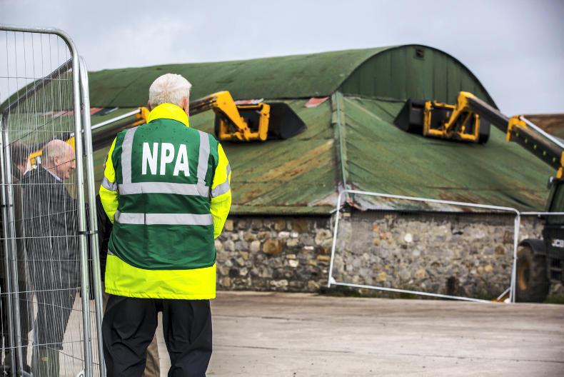
Teleporters used to secure a corrigated roof at the National Ploughing Championships 2018. \ Philip Doyle
ADVERTISEMENT
Met Éireann lifted its orange warning for the west and north at 1pm Wednesday, and has confirmed to the Irish Farmers Journal that a lower-level nationwide yellow warning is on course to expire at 5pm.
Strongest gusts to 8:30am (km/h):
143 Mace Head (Galway) 124 Newport (Mayo) 107 Belmullet 106 Claremorris 106 Valentia 104 Roches Point (Cork) 96 Athenry
In Northern Ireland, an amber warning remains in place until 6pm as Storm Ali tracks northeastwards. The warning is expected to be downgraded to status yellow until 10pm.
Aisling Butler, forecaster with Met Éireann, said conditions remain blustery and fresh, but the damaging gusts have moved away.
“Wind wise, tomorrow [Thursday], it looks like there will be light to fresh breezes, but there will be widespread heavy rain from the afternoon through the evening. Conditions are likely to worsen as the day goes on,” she said.
There is a risk of spot flooding in Munster and south Leinster. Around 15mm of rain is forecast at the site of the National Ploughing Championships in Screggan, Co Offaly from 2pm on Wednesday.
The outlook for the rest of this week is mixed, with strong winds and heavy rain forecast at times.
This content is available to digital subscribers and loyalty code users only. Sign in to your account, use the code or subscribe to get unlimited access.
The reader loyalty code gives you full access to the site from when you enter it until the following Wednesday at 9pm. Find your unique code on the back page of Irish Country Living every week.
CODE ACCEPTED
You have full access to the site until next Wednesday at 9pm.
CODE NOT VALID
Please try again or contact support.
Met Éireann lifted its orange warning for the west and north at 1pm Wednesday, and has confirmed to the Irish Farmers Journal that a lower-level nationwide yellow warning is on course to expire at 5pm.
Strongest gusts to 8:30am (km/h):
143 Mace Head (Galway) 124 Newport (Mayo) 107 Belmullet 106 Claremorris 106 Valentia 104 Roches Point (Cork) 96 Athenry
In Northern Ireland, an amber warning remains in place until 6pm as Storm Ali tracks northeastwards. The warning is expected to be downgraded to status yellow until 10pm.
Aisling Butler, forecaster with Met Éireann, said conditions remain blustery and fresh, but the damaging gusts have moved away.
“Wind wise, tomorrow [Thursday], it looks like there will be light to fresh breezes, but there will be widespread heavy rain from the afternoon through the evening. Conditions are likely to worsen as the day goes on,” she said.
There is a risk of spot flooding in Munster and south Leinster. Around 15mm of rain is forecast at the site of the National Ploughing Championships in Screggan, Co Offaly from 2pm on Wednesday.
The outlook for the rest of this week is mixed, with strong winds and heavy rain forecast at times.
If you would like to speak to a member of our team, please call us on 01-4199525.
Link sent to your email address
We have sent an email to your address. Please click on the link in this email to reset your password. If you can't find it in your inbox, please check your spam folder. If you can't find the email, please call us on 01-4199525.
ENTER YOUR LOYALTY CODE:
The reader loyalty code gives you full access to the site from when you enter it until the following Wednesday at 9pm. Find your unique code on the back page of Irish Country Living every week.


SHARING OPTIONS