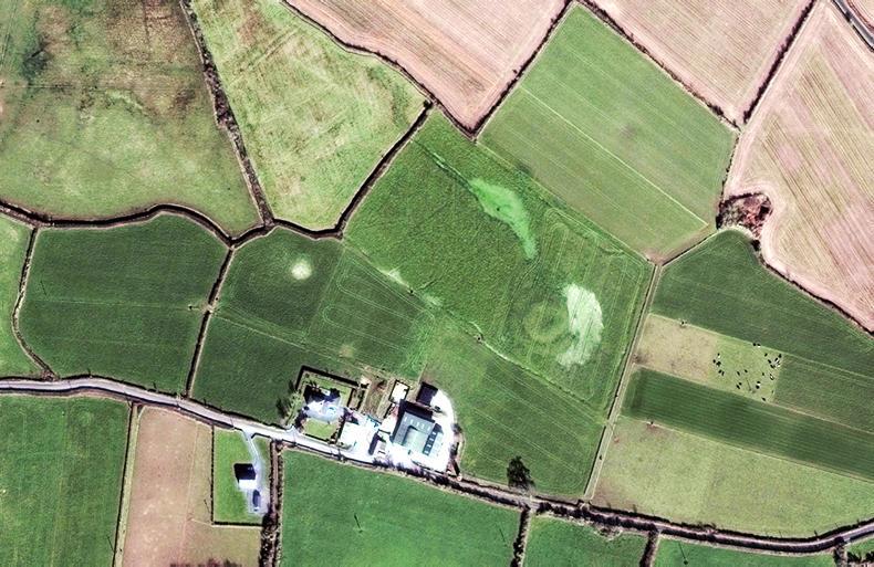
Satellite inspection of farms could soon be ramped up to every three to five days all year round, according to work underway in the Department of Agriculture. \ Digital Globe
ADVERTISEMENT
The satellite monitoring of farms is set to be ramped up, with every farm to be photographed and assessed every three to five days all year round as part of plans for the next CAP.
The European Commission is pushing for a satellite monitoring system that will provide real-time land eligibility data for all farms.
At present, only 5% of farms are inspected for land eligibility annually.
ADVERTISEMENT
This inspection process would be automatic, carried out by a computer rather than a Department inspector
Documents seen by the Irish Farmers Journal reveal that the Department of Agriculture has started scoping out the feasibility of such a system. It will require all 1.1m land parcels in the State to be continuously tracked by the EU’s satellites.
These satellite images would then be used to grade farmers’ declared area on a traffic-light system: green for eligible for payment, red for ineligible and yellow for inconclusive.
This inspection process would be automatic, carried out by a computer rather than a Department inspector. Farmers would have the opportunity to appeal decisions.
Area-based schemes
The system will apply to all area-based schemes including direct payments under the Basic Payment Scheme (BPS), Areas of Natural Constraint (ANC) payments and the Young Farmer Scheme.
This content is available to digital subscribers and loyalty code users only. Sign in to your account, use the code or subscribe to get unlimited access.
The reader loyalty code gives you full access to the site from when you enter it until the following Wednesday at 9pm. Find your unique code on the back page of Irish Country Living every week.
CODE ACCEPTED
You have full access to the site until next Wednesday at 9pm.
CODE NOT VALID
Please try again or contact support.
The satellite monitoring of farms is set to be ramped up, with every farm to be photographed and assessed every three to five days all year round as part of plans for the next CAP.
The European Commission is pushing for a satellite monitoring system that will provide real-time land eligibility data for all farms.
At present, only 5% of farms are inspected for land eligibility annually.
This inspection process would be automatic, carried out by a computer rather than a Department inspector
Documents seen by the Irish Farmers Journal reveal that the Department of Agriculture has started scoping out the feasibility of such a system. It will require all 1.1m land parcels in the State to be continuously tracked by the EU’s satellites.
These satellite images would then be used to grade farmers’ declared area on a traffic-light system: green for eligible for payment, red for ineligible and yellow for inconclusive.
This inspection process would be automatic, carried out by a computer rather than a Department inspector. Farmers would have the opportunity to appeal decisions.
Area-based schemes
The system will apply to all area-based schemes including direct payments under the Basic Payment Scheme (BPS), Areas of Natural Constraint (ANC) payments and the Young Farmer Scheme.
If you would like to speak to a member of our team, please call us on 01-4199525.
Link sent to your email address
We have sent an email to your address. Please click on the link in this email to reset your password. If you can't find it in your inbox, please check your spam folder. If you can't find the email, please call us on 01-4199525.
ENTER YOUR LOYALTY CODE:
The reader loyalty code gives you full access to the site from when you enter it until the following Wednesday at 9pm. Find your unique code on the back page of Irish Country Living every week.


SHARING OPTIONS