


The European Space Agency (ESA) has two missions that are being used to monitor farms – Sentinel-1 and Sentinel-2. Data from each of the two missions is designed to complement the other. The satellite pair passes over Europe at least every two days.
“Thanks to the Sentinels’ frequent revisits and their high-resolution data, farming activities and crop state can be monitored easily,” ESA’s Benjamin Koetz, who is part of the Sen4CAP team, said.
“The data can be used, for example, to identify the type of crop planted and how it grows through the season and when it is harvested.”
The satellites can detect whether or not a farmer is meeting greening requirements, for example. Observations from the Sentinels are analysed with machine-learning algorithms to provide national crop-type maps throughout the season.
This does not extend to animals, however. Current civil satellites do not have sufficient capabilities to detect animals in the fields, the ESA said.
There are two satellites as part of the Sentinel-1 mission. Sentinel-1A was launched on 3 April 2014 and Sentinel-1B on 25 April 2016.

Sentinel-1B lifted off on a Soyuz rocket, flight VS14, from Europe’s Spaceport in French Guiana on 25 April 21:02 GMT \ ESA–Manuel Pedoussaut
As a constellation of two satellites orbiting 180° apart, the mission images the entire Earth every six days. They also carry a laser to transmit data to the geostationary European Data Relay System for continual data delivery.
They carry an advanced radar instrument to provide an all-weather, day-and-night supply of imagery of Earth’s surface. Sentinel-1 is a Synthetic Aperture Radar (SAR) instrument measuring in the microwave wavelength (C-band).
The satellites can deliver data on crop biomass and detect when a crop has been harvested. Their grid resolution is 10m.
“Such a resolution allows to resolve the majority of fields in Europe, although there will be always a challenge to cover very small fields,” a spokesperson for the ESA said.
Of course, it is not just focused on agriculture. The mission monitors Arctic sea ice, surveillance of the marine environment, including oil-spill monitoring and ship detection for maritime security, monitoring land-surface for motion risks, mapping for forest, water and soil management and mapping to support humanitarian aid and crisis situations.
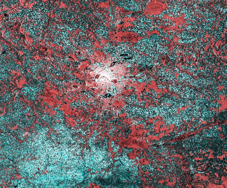
Paris appears as a cluster of bright radar reflections along the Seine River in this radar image from Sentinel-1A. \ Copernicus data/ESA (2015)
Sentinel-2A was launched on 23 June 2015 and Sentinel-2B followed on 7 March 2017. Again, they orbit 180° apart and cover all Earth’s land surfaces every five days at the equator. They cover Europe every three to four days.

Sentinel-2A fully integrated at IABG’s facilities in Ottobrunn, Germany on 24 February 2015, before being packed up and shipped to French Guiana for launch. \ ESA–S. Corvaja
The Sentinel-2 satellites carry high-resolution cameras, images from which can be used to distinguish between different crop types, assess crop health and monitor land-use change. Similar to Sentinel-1, it covers Europe every three to four days.
Their grid resolution is 10 to 20m.
Sentinel-2 carry a wide swath (290km) high-resolution multispectral imager with 13 spectral bands to gain a perspective of our land and vegetation. The mission mainly provides information for agricultural and forestry practices. Satellite images can be used to determine various plant indices such as leaf area chlorophyll and water content indexes. It can be used, for example, to predict crop yields.

The detail of France’s capital city is clearly visible in this Sentinel-2A image. \ Copernicus Sentinel data (2015)/ESA
It also provides information on pollution in lakes and coastal waters, images of floods, volcanic eruptions and landslides which contribute to disaster mapping and humanitarian relief efforts.

Ships queuing along the Danube river near the Romanian town of Zimnicea, captured by Sentinel-2A on 26 July 2015. \ Copernicus Sentinel data (2015)/ESA

SHARING OPTIONS