The Department of Agriculture expects to roll out its new land parcel information system (LPIS) to all 26 counties in the Republic of Ireland by 2022.
The new LPIS tool will be called AgLand, according to the Department of Agriculture.
The mapping system will underpin many of the schemes rolled out by the Department, such as the Basic Payment Scheme, ANC, GLAS and afforestation schemes.
Department documents seen by the Irish Farmers Journal say that “the timelines for delivery are going to be extremely tight” over the coming years, despite the Department acknowledging that the current system is “dated” and “in need of a major update”.
Below par
EU audits have highlighted shortcomings in the current mapping system in use (LPIS) and the Department has given a commitment to the European Commission that the non-conformities will be addressed via a fundamental restructuring of the LPIS.

The objective of the project is to develop a new mapping system that is up to date, compatible with best-available technologies, fully functional and compliant with regulatory requirements.
Accurate
This new mapping tool “will give a more accurate reflection of the land parcel boundaries” that are used in range of Department schemes, according to the Department.
This year, the system is being rolled out in Meath, Monaghan, Cavan, Leitrim and Longford. It was trialled in Louth in 2019.
The Department is notifying farmers affected by the changes and a series of public information meetings will be held in the coming months.
What will be different in the new system
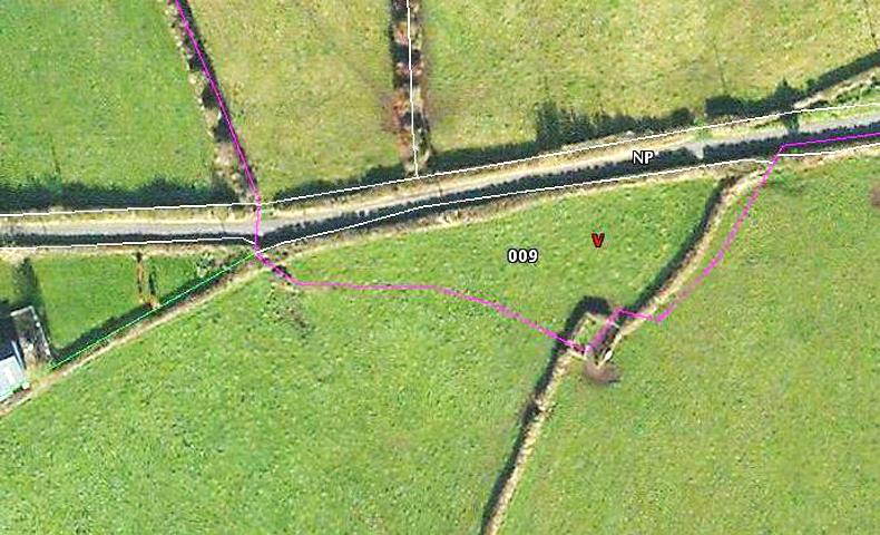
As previously reported by the Irish Farmers Journal, in the new system land parcels will be correctly aligned with real world features, such as hedgerows.
On the current maps, farmers who have land parcels in more than one townland are split along the townland line. The new system will see these parcels merged.
In areas where a road or river runs through a land parcel, the new system will split it into two separate parcels.
Read more
Payments mapping review – what has changed?
New maps may change BPS claims
The Department of Agriculture expects to roll out its new land parcel information system (LPIS) to all 26 counties in the Republic of Ireland by 2022.
The new LPIS tool will be called AgLand, according to the Department of Agriculture.
The mapping system will underpin many of the schemes rolled out by the Department, such as the Basic Payment Scheme, ANC, GLAS and afforestation schemes.
Department documents seen by the Irish Farmers Journal say that “the timelines for delivery are going to be extremely tight” over the coming years, despite the Department acknowledging that the current system is “dated” and “in need of a major update”.
Below par
EU audits have highlighted shortcomings in the current mapping system in use (LPIS) and the Department has given a commitment to the European Commission that the non-conformities will be addressed via a fundamental restructuring of the LPIS.

The objective of the project is to develop a new mapping system that is up to date, compatible with best-available technologies, fully functional and compliant with regulatory requirements.
Accurate
This new mapping tool “will give a more accurate reflection of the land parcel boundaries” that are used in range of Department schemes, according to the Department.
This year, the system is being rolled out in Meath, Monaghan, Cavan, Leitrim and Longford. It was trialled in Louth in 2019.
The Department is notifying farmers affected by the changes and a series of public information meetings will be held in the coming months.
What will be different in the new system
As previously reported by the Irish Farmers Journal, in the new system land parcels will be correctly aligned with real world features, such as hedgerows.
On the current maps, farmers who have land parcels in more than one townland are split along the townland line. The new system will see these parcels merged.
In areas where a road or river runs through a land parcel, the new system will split it into two separate parcels.
Read more
Payments mapping review – what has changed?
New maps may change BPS claims


 This is a subscriber-only article


SHARING OPTIONS: