

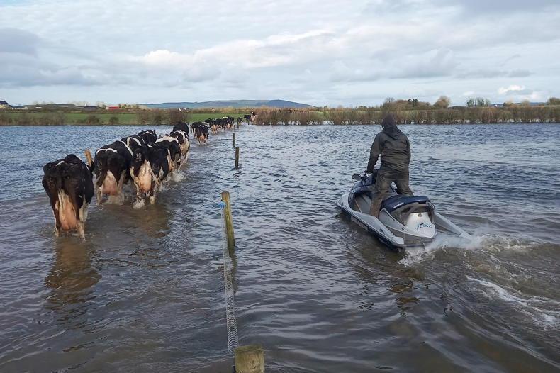
Images shared by farmers around the country track the damage caused at the very time when they would have been hoping for drying weather to allow early field access for activities including slurry spreading.
The rainfall hit the west coast first. This mixed farmer in Killaloe, Co Clare, reported nearly 3in of rain in two hours.
70mm rain in 2 hours pic.twitter.com/XNsygiKHPL
ADVERTISEMENT— ROB (@ei3grb_rob) January 21, 2018
In neighbouring Co Limerick, the Salesian college at Pallaskenry saw similar conditions.
It's definitely wet when this flows from a field of winter cabbage and onto the road pic.twitter.com/lEk6Xw9Ex3
— Salesian Ag College (@SalesianAg) January 21, 2018
On the Galway/Roscommon border, dairy farmer Ed Payne tracked water accumulation through the rise in the turlough on his farm.
Yes but the dogs and their bowls were under cover.
— Ed Payne (@grazyfarmer) January 21, 2018
The turlough is on the rise though. Best measure we have. pic.twitter.com/ebYGWRy1O9
It was a similar story from Co Tipperary pedigree sheep farmers Noel and Áine Clancy.
You may teach them to swim. Go away rain! pic.twitter.com/YzBPAVFU4p
— The Tipperary Farmer (@nbclancy) January 21, 2018
Moving east later in the day, Irish Farmers Journal farmer writers Ronan Delany in Co Meath and Bill O'Keeffe in Co Kilkenny exchanged pictures of the aftermath.
That's nothing! pic.twitter.com/fYg7SWJ8M7
— Bill O Keeffe(@billokeeffe) January 21, 2018
Bill captured more in this video.
Letting off as much as we can for ye over here! pic.twitter.com/bs5kK3XD30
— Bill O Keeffe (@billokeeffe) January 21, 2018
This attracted this response from dairy farmer Ed Payne, also in Co Kilkenny:
Holding back as much as I can. pic.twitter.com/UOAIpgnhMe
— paudie brennan (@paudiebrenna) January 21, 2018
The latest rain hit land already saturated with water. All of Met Éireann's weather stations recorded higher than normal precipitation in the seven weeks prior to Sunday. Those in the north and west received around double the normal rainfall, with Claremorris, Co Mayo, and Shannon Airport, Co Clare, topping 60mm and recording more than twice their normal weekly amounts.
Met Éireann is now forecasting that the last of this rain will clear by Sunday night.
Surface water will continue to affect many roads this afternoon but the heavy rain will gradually turn more to showers before finally clearing the east coast by evening. Highest temperatures today will range from 8°C to 13°C, with blustery southwesterly winds. pic.twitter.com/0kAP93IfF8
— Met Éireann (@MetEireann) January 21, 2018
The outlook is for dry weather for the next two days, but more rain is forecast midweek.
In pictures: emergency hay reaches Donegal islands
SHARING OPTIONS