In 2017, more than 16,000 Irish farms were monitored by satellites located almost 800km away in space.
The “eye in the sky” has been used to monitor farms since the late 1990s, but there are sweeping changes on the way for how satellites and other examples of smart technology affect farmers.
Zones
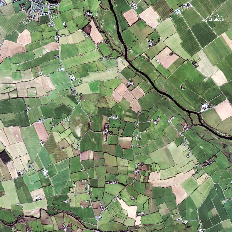
Each year more than 30 zones are monitored in Ireland using images taken by the American Worldview and GeoEye satellites, owned by Digital Globe, and by the French SPOT (Satellite Pour l’Observation de la Terre).
Each of the zones are around 200 square kilometres in size and irregular in shape.
The zones are selected by the country’s paying agency. In Ireland’s case, this is the Department of Agriculture. The zones are selected from right across the country and change every year.

The location of each zone is confidential until the inspections for that year are complete. The 48 satellite inspection zones for 2016 are shown on the map.
According to the European Commission, this equated to almost 18,000 square kilometres of land and 16,300 farms.
Last year, around 16,000 farms were monitored by satellite, accounting for 90% of the total checks on area-based payments to farmers. That was an increase of 20% on the previous year.
What can satellites see?
Each country can choose what type of imagery it wants to use and how many images it wants to pay for.
In Ireland’s case, the Department of Agriculture pays for high-resolution imagery. The higher the resolution, the higher the quality of the image. In Ireland’s satellite imagery, each pixel of the image equates to a 50cm diameter section of your farm.
At this resolution, it is possible on a clear day to see and count sheep and cattle in the field, as well as see water troughs and other features.
Crop changes like cutting of silage, hedges, trees and landscape features like ponds, old forts and farm buildings and vehicles are easy to see.
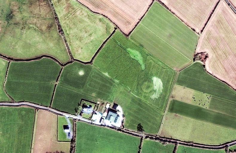
The image above clearly shows the dwelling house and the farm sheds on a Tipperary farm. It also shows silage bales stacked in the yard, cows grazing in the paddocks, a circular lios (old fort), and differences in soil type where the fields regularly flood in winter.
In recent years, Ireland has opted to pay for two very high resolution images to be taken of each zone at two separate times of year, in spring and late summer.
Other countries choose to use one high resolution image in spring and follow up with an area check. Others choose to use satellite images taken on as many as four dates in the year.
The Department of Agriculture examines these images and if there is any doubt about what officials can see on the image, they may follow up with an on-farm inspection. For example, where there are trees or scrub on the boundary of a land parcel, they may visit the farm in person.
The future
Big changes are on the way for how satellites are used by the European Commission to monitor farming.
Switching to a new satellite system means that every farmer can be monitored every year.
And, since 22 May this year, each member state can completely replace on-farm inspection of land for area-based CAP payments with satellite-only inspection.
It is up to each country to decide whether it switches to satellite-only checks or not.
The images will come free of charge from Copernicus Sentinel satellites.
Copernicus is the European Union’s earth observation programme, dubbed “Europe’s eyes on Earth”.
Two Copernicus Sentinel-2 satellites circle on opposite sides of Earth, sweeping across 290km of the Earth’s surface. Together they can image the globe every five days and image Europe every two to three days.
At this frequency and using free imagery, each country’s Department of Agriculture will be able to monitor all farms every year at no extra cost.
Ten European member states have already started using the Sentinel imagery in 2018, including Italy, Belgium Flanders, France, Denmark and the Netherlands. There has been no official announcement yet from Ireland about whether it will trial the new satellite pictures this year.
What is coming down the tracks?
The European Commission is moving towards using more technology in farm monitoring. In future, it will allow farmers and agriculture ministries to use geo-tagged photography and information from drones as part of their farm checks.
Geo-tag photography would see farmers use their smartphones to correlate their farm information with the satellite data.
Philippe Loudjani from the European Commission’s Joint Research Centre told the Irish Farmers Journal this could be used for farm schemes such as GLAS. “If a farmer has to mow a field before a certain date, the administration [Department of Agriculture] could send him a reminder message to his phone two weeks before the date. When the field is mowed, the farmer could send a photograph from the mown field using his smartphone.
“The digital photograph file would contain the date, time and exact location of the field. This could be sent to administration, correlated with satellite information and included in the farmer’s file,” explained Loudjani.
Satellite measurements of the average height of vegetation in a field can be used to show how a crop is growing, what height it is and confirm when it is harvested.
“In theory, this would mean that the administration would never need to go to a farm to check on crops,” he added.
Other uses
While the satellite images from the Sentinels will be available to farmers and the Department of Agriculture free of charge, it will also be available to everyone else free of charge.
This includes environmental agencies, non-governmental agencies, lobby groups and anyone else who wants to look closely at farms. “The data will be available to everyone to use, process and gather evidence,” said Loudjani.
“Some of those may question the farming practices and everyone will be able to make an assessment.”
While the Commission official said that it would not be 100% accurate on where slurry was spread, it could show spreading of sludge on crops where they were flattened by the spreading.
“The imagery will show where there is a change of status on the land,” he added.
In focus: satellites
Copernicus launched twin satellites, Sentinel-2A and Sentinel-2B, into space in June 2015 and March 2017. Their objective is to gather information to produce land cover and land change maps. Other Sentinel satellites monitor greenhouse gases, the ozone layer, sea levels and currents, ice sheets, major fires and are even used for border security and tracking migrants. The Sentinels follow the sun’s orbit and are programmed to always be at a very specific altitude and angle to the earth to ensure they have the best light from the sun, while minimising the effect of shadows from mountains and buildings, as well as cloud cover. 
The WorldView-2 satellite acts like a paintbrush, sweeping back and forth to collect very large areas of imagery in a single pass. It can collect nearly a million square kilometres every day. \ DigitalGlobe
Each of the Sentinel satellites weighs 1.2t. They have a lifespan of 7.25 years but enough batteries and propellants to allow 12 years of operations, including end of life de-orbiting manoeuvres. They orbit the Earth at 786km from its surface. The two Copernicus Sentinel-2 satellites circle on opposite sides of Earth. With each providing a 290km-wide swath, together they can image the globe every five days and image Europe every two to three days.The same satellite currently used to monitor farms in Ireland was recently used to confirm the massacre of a village in Myanmar in southeast Asia. Satellite images from DigitalGlobe were used by news agency AP to show the village before and after hundreds of homes were destroyed and up to 400 people killed.The European Commission last week proposed a €16bn budget for space activities for 2021 to 2027. Ireland is one of 22 member states that fund the European Space Agency, which was created in 1975. Malta and the Netherlands used satellites to complete 100% of their farm checks on land-based farm schemes in 2017. Portugal was the least reliant on satellites, with just over 20% of farms checked using space machinery. Read more
Satellites inspecting farms – what can they see?
In 2017, more than 16,000 Irish farms were monitored by satellites located almost 800km away in space.
The “eye in the sky” has been used to monitor farms since the late 1990s, but there are sweeping changes on the way for how satellites and other examples of smart technology affect farmers.
Zones
Each year more than 30 zones are monitored in Ireland using images taken by the American Worldview and GeoEye satellites, owned by Digital Globe, and by the French SPOT (Satellite Pour l’Observation de la Terre).
Each of the zones are around 200 square kilometres in size and irregular in shape.
The zones are selected by the country’s paying agency. In Ireland’s case, this is the Department of Agriculture. The zones are selected from right across the country and change every year.
The location of each zone is confidential until the inspections for that year are complete. The 48 satellite inspection zones for 2016 are shown on the map.
According to the European Commission, this equated to almost 18,000 square kilometres of land and 16,300 farms.
Last year, around 16,000 farms were monitored by satellite, accounting for 90% of the total checks on area-based payments to farmers. That was an increase of 20% on the previous year.
What can satellites see?
Each country can choose what type of imagery it wants to use and how many images it wants to pay for.
In Ireland’s case, the Department of Agriculture pays for high-resolution imagery. The higher the resolution, the higher the quality of the image. In Ireland’s satellite imagery, each pixel of the image equates to a 50cm diameter section of your farm.
At this resolution, it is possible on a clear day to see and count sheep and cattle in the field, as well as see water troughs and other features.
Crop changes like cutting of silage, hedges, trees and landscape features like ponds, old forts and farm buildings and vehicles are easy to see.
The image above clearly shows the dwelling house and the farm sheds on a Tipperary farm. It also shows silage bales stacked in the yard, cows grazing in the paddocks, a circular lios (old fort), and differences in soil type where the fields regularly flood in winter.
In recent years, Ireland has opted to pay for two very high resolution images to be taken of each zone at two separate times of year, in spring and late summer.
Other countries choose to use one high resolution image in spring and follow up with an area check. Others choose to use satellite images taken on as many as four dates in the year.
The Department of Agriculture examines these images and if there is any doubt about what officials can see on the image, they may follow up with an on-farm inspection. For example, where there are trees or scrub on the boundary of a land parcel, they may visit the farm in person.
The future
Big changes are on the way for how satellites are used by the European Commission to monitor farming.
Switching to a new satellite system means that every farmer can be monitored every year.
And, since 22 May this year, each member state can completely replace on-farm inspection of land for area-based CAP payments with satellite-only inspection.
It is up to each country to decide whether it switches to satellite-only checks or not.
The images will come free of charge from Copernicus Sentinel satellites.
Copernicus is the European Union’s earth observation programme, dubbed “Europe’s eyes on Earth”.
Two Copernicus Sentinel-2 satellites circle on opposite sides of Earth, sweeping across 290km of the Earth’s surface. Together they can image the globe every five days and image Europe every two to three days.
At this frequency and using free imagery, each country’s Department of Agriculture will be able to monitor all farms every year at no extra cost.
Ten European member states have already started using the Sentinel imagery in 2018, including Italy, Belgium Flanders, France, Denmark and the Netherlands. There has been no official announcement yet from Ireland about whether it will trial the new satellite pictures this year.
What is coming down the tracks?
The European Commission is moving towards using more technology in farm monitoring. In future, it will allow farmers and agriculture ministries to use geo-tagged photography and information from drones as part of their farm checks.
Geo-tag photography would see farmers use their smartphones to correlate their farm information with the satellite data.
Philippe Loudjani from the European Commission’s Joint Research Centre told the Irish Farmers Journal this could be used for farm schemes such as GLAS. “If a farmer has to mow a field before a certain date, the administration [Department of Agriculture] could send him a reminder message to his phone two weeks before the date. When the field is mowed, the farmer could send a photograph from the mown field using his smartphone.
“The digital photograph file would contain the date, time and exact location of the field. This could be sent to administration, correlated with satellite information and included in the farmer’s file,” explained Loudjani.
Satellite measurements of the average height of vegetation in a field can be used to show how a crop is growing, what height it is and confirm when it is harvested.
“In theory, this would mean that the administration would never need to go to a farm to check on crops,” he added.
Other uses
While the satellite images from the Sentinels will be available to farmers and the Department of Agriculture free of charge, it will also be available to everyone else free of charge.
This includes environmental agencies, non-governmental agencies, lobby groups and anyone else who wants to look closely at farms. “The data will be available to everyone to use, process and gather evidence,” said Loudjani.
“Some of those may question the farming practices and everyone will be able to make an assessment.”
While the Commission official said that it would not be 100% accurate on where slurry was spread, it could show spreading of sludge on crops where they were flattened by the spreading.
“The imagery will show where there is a change of status on the land,” he added.
In focus: satellites
Copernicus launched twin satellites, Sentinel-2A and Sentinel-2B, into space in June 2015 and March 2017. Their objective is to gather information to produce land cover and land change maps. Other Sentinel satellites monitor greenhouse gases, the ozone layer, sea levels and currents, ice sheets, major fires and are even used for border security and tracking migrants. The Sentinels follow the sun’s orbit and are programmed to always be at a very specific altitude and angle to the earth to ensure they have the best light from the sun, while minimising the effect of shadows from mountains and buildings, as well as cloud cover.
The WorldView-2 satellite acts like a paintbrush, sweeping back and forth to collect very large areas of imagery in a single pass. It can collect nearly a million square kilometres every day. \ DigitalGlobe
Each of the Sentinel satellites weighs 1.2t. They have a lifespan of 7.25 years but enough batteries and propellants to allow 12 years of operations, including end of life de-orbiting manoeuvres. They orbit the Earth at 786km from its surface. The two Copernicus Sentinel-2 satellites circle on opposite sides of Earth. With each providing a 290km-wide swath, together they can image the globe every five days and image Europe every two to three days.The same satellite currently used to monitor farms in Ireland was recently used to confirm the massacre of a village in Myanmar in southeast Asia. Satellite images from DigitalGlobe were used by news agency AP to show the village before and after hundreds of homes were destroyed and up to 400 people killed.The European Commission last week proposed a €16bn budget for space activities for 2021 to 2027. Ireland is one of 22 member states that fund the European Space Agency, which was created in 1975. Malta and the Netherlands used satellites to complete 100% of their farm checks on land-based farm schemes in 2017. Portugal was the least reliant on satellites, with just over 20% of farms checked using space machinery. Read more
Satellites inspecting farms – what can they see?


 This is a subscriber-only article


SHARING OPTIONS: